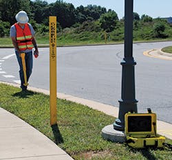
Preventing injury and equipment damage is important for every contractor, especially if the job requires excavation. Fortunately utility detection devices have improved in recent years. More sensitive sensors and increase computing power help excavators map underground utilities before a shovel hits the dirt.
Utility detection devices, sometimes called locators, are used detect underground utilities. The utility detection devices which are most often seen by resemble wands and are carried by workers who walk along with them. Readers may be familiar with seeing beachcombers with metal detectors walking the beach at low tide to find treasures thrown up by the ocean.
For many contractors, the question is whether to have their own crews do the detecting or hire an outside professional. That is a decision that depends on your particular circumstances. Neither method (in-house or outsource) is necessarily better than the other if it is done correctly. Cost is a practical consideration, but so is efficiency.
Preventing injury and equipment damage is important for every contractor, especially if the job requires excavation. Fortunately utility detection devices have improved in recent years. More sensitive sensors and increase computing power help excavators map underground utilities before a shovel hits the dirt. Utility detection devices, sometimes called locators, are used detect underground utilities. The utility detection devices which are most often seen by resemble wands and are carried by workers who walk along with them. Readers may be familiar with seeing beachcombers with metal detectors walking the beach at low tide to find treasures thrown up by the ocean. For many contractors, the question is whether to have their own crews do the detecting or hire an outside professional. That is a decision that depends on your particular circumstances. Neither method (in-house or outsource) is necessarily better than the other if it is done correctly. Cost is a practical consideration, but so is efficiency. [text_ad] Something that is sometimes overlooked is that your crews should know what the different colors of markers indicate. Make sure your employees know what red, yellow, and blue mean…or why bother to be careful? A couple of years ago, in the alley behind my office, a young man with a large excavator was about to plunge the blade into the ground decorated with colorful markers. I asked him if he knew what yellow and red marks meant. “They mean that somebody has been here with one of this sticks to see what’s below,” he replied. That was the sum total of his knowledge. (He did wait to dip his blade in the ground until he understood the markers—and he’s still alive.) An advance in technique that must have made a huge difference to detecting underground utilities is the addition of wheels to the locating device. Even if the locator is lightweight, it will only seem so for a short part of the day. Carrying anything all day will be heavy work. Among wheeled locators that have earned success in recent years has been the Noggin SmartChariot from Sensors & Software. This device is usually hauled behind a vehicle and has proven especially valuable for checking subsurface conditions like those of bridges and pavement structures. It offers a high range of resolution, with GPR in 250, 500, and 1000 MHz units and has an integrated odometer for the collection of data at equal intervals along the survey line. The sensors have a suspension ride just above the ground surface. Pavement evaluations are not strictly utility hunting but locating devices like the Noggin SmartChariot can save money and time on the same principles. The evaluations usually involve expensive, labor-intensive, and destructive coring of the road structure to get estimates of the asphalt and granular thicknesses. Typically, cores are collected at set intervals to cover the length of the road; there are often too may cores specified. A GPR survey before coring gives us a solid basis for determining how many cores are really necessary and where they should be placed. If the GPR survey shows that the granular and asphalt boundaries show minimal spatial variation, only one core may be required. If there are large variations in the subsurface, cores can be positioned where there is thick, thin, or anomalous layering to understand the subsurface in detail. The MALA Easy Locator HDR is one of the most successful wheeled GPR locators. The original Easy Locator, when it entered the market decades ago, could claim to have changed the entire approach to GPR utility detection. Today the machine looks almost identical as the original, but “the core technology is completely reworked and new, with patents pending,” asserts Bernth Johansson, head of research and development at MALA. [text_ad use_post='27747'] “With a performance that truly speaks for itself in both data quality and speed, today’s Easy Locator delivers results with much more detail, and with more than a 20% increase in depth of penetration in normal soil. We have found unique ways to drastically improve the dynamic range and signal bandwidth of the system. In plain English, we have developed a system that penetrates deeper while, at the same time, delivers higher resolution in the shallow regions. It is like having a system with several antennas built into one.”It detects metallic and non-metallic utilities, offers more than 14 hours of continuous operating time with an operating speed more than 15 mph. The machine’s scan rate can be more than 1,024 scans per second, and it has single button operation. Another brand name that has been in the utility detection business for a long time (since 1921 for related challenges) is McLaughlin. The Verifier G2 is perhaps their best-known product today, especially as the transmitter is completely waterproof and now offers a 3-year warranty, including water damage. This utility detection device is easy to use. The Peak Mode of the receiver will pinpoint locations for accurate excavation and depth calculations, while the Null Mode will let you do fast tracing of lines with its clear guiding arrows. The Verifier G2 offers four frequencies to give you the most suitable for the type of service, distance, and grounding conditions of your locate. (The four frequencies are: 512 Hz, 9.5 kHz, 38 kHz, and 80 kHz.) A feature called Depth Readout and Current Measurement Index (CMI) helps the user to identify the target line in congested areas (and also, by report, helps build operator confidence). Depth capacity (as shown in test conditions) is 30 feet for extreme depth and noise conditions, 0–16 feet for normal conditions. Another interesting feature of today’s Verifier G2 is the new data storage and time stamp feature that includes a built-in clock to record date, time, depth reading, and current measurement value of your work in detection. The unit can store up to 400 depth readings and may be downloaded to any PC. There are a lot of questions, aren’t there? If you’re just starting into underground utility detection, you’ll need to do some research. Your dealer should be able to help, but you may also find it useful to study some of the excellent websites (for the companies mentioned in this article and for others, because there are many good manufacturers) for features and benefits. You can be sure that the instrumentation you need is available, but it may not be just one product or one technique. Price will always be a consideration, but not the only one. What you need is the right equipment for your situations, or the external source who has the right equipment and efficiency to do what needs to be done at your sites.Something that is sometimes overlooked is that your crews should know what the different colors of markers indicate. Make sure your employees know what red, yellow, and blue mean…or why bother to be careful?
A couple of years ago, in the alley behind my office, a young man with a large excavator was about to plunge the blade into the ground decorated with colorful markers. I asked him if he knew what yellow and red marks meant.
“They mean that somebody has been here with one of this sticks to see what’s below,” he replied.
That was the sum total of his knowledge. (He did wait to dip his blade in the ground until he understood the markers—and he’s still alive.)
An advance in technique that must have made a huge difference to detecting underground utilities is the addition of wheels to the locating device. Even if the locator is lightweight, it will only seem so for a short part of the day. Carrying anything all day will be heavy work.
Among wheeled locators that have earned success in recent years has been the Noggin SmartChariot from Sensors & Software. This device is usually hauled behind a vehicle and has proven especially valuable for checking subsurface conditions like those of bridges and pavement structures. It offers a high range of resolution, with GPR in 250, 500, and 1000 MHz units and has an integrated odometer for the collection of data at equal intervals along the survey line. The sensors have a suspension ride just above the ground surface.
Pavement evaluations are not strictly utility hunting but locating devices like the Noggin SmartChariot can save money and time on the same principles. The evaluations usually involve expensive, labor-intensive, and destructive coring of the road structure to get estimates of the asphalt and granular thicknesses. Typically, cores are collected at set intervals to cover the length of the road; there are often too may cores specified. A GPR survey before coring gives us a solid basis for determining how many cores are really necessary and where they should be placed. If the GPR survey shows that the granular and asphalt boundaries show minimal spatial variation, only one core may be required. If there are large variations in the subsurface, cores can be positioned where there is thick, thin, or anomalous layering to understand the subsurface in detail.
The MALA Easy Locator HDR is one of the most successful wheeled GPR locators. The original Easy Locator, when it entered the market decades ago, could claim to have changed the entire approach to GPR utility detection. Today the machine looks almost identical as the original, but “the core technology is completely reworked and new, with patents pending,” asserts Bernth Johansson, head of research and development at MALA.
“With a performance that truly speaks for itself in both data quality and speed, today’s Easy Locator delivers results with much more detail, and with more than a 20% increase in depth of penetration in normal soil. We have found unique ways to drastically improve the dynamic range and signal bandwidth of the system. In plain English, we have developed a system that penetrates deeper while, at the same time, delivers higher resolution in the shallow regions. It is like having a system with several antennas built into one.”It detects metallic and non-metallic utilities, offers more than 14 hours of continuous operating time with an operating speed more than 15 mph. The machine’s scan rate can be more than 1,024 scans per second, and it has single button operation.
Another brand name that has been in the utility detection business for a long time (since 1921 for related challenges) is McLaughlin. The Verifier G2 is perhaps their best-known product today, especially as the transmitter is completely waterproof and now offers a 3-year warranty, including water damage. This utility detection device is easy to use. The Peak Mode of the receiver will pinpoint locations for accurate excavation and depth calculations, while the Null Mode will let you do fast tracing of lines with its clear guiding arrows. The Verifier G2 offers four frequencies to give you the most suitable for the type of service, distance, and grounding conditions of your locate. (The four frequencies are: 512 Hz, 9.5 kHz, 38 kHz, and 80 kHz.) A feature called Depth Readout and Current Measurement Index (CMI) helps the user to identify the target line in congested areas (and also, by report, helps build operator confidence). Depth capacity (as shown in test conditions) is 30 feet for extreme depth and noise conditions, 0–16 feet for normal conditions. Another interesting feature of today’s Verifier G2 is the new data storage and time stamp feature that includes a built-in clock to record date, time, depth reading, and current measurement value of your work in detection. The unit can store up to 400 depth readings and may be downloaded to any PC.
There are a lot of questions, aren’t there? If you’re just starting into underground utility detection, you’ll need to do some research. Your dealer should be able to help, but you may also find it useful to study some of the excellent websites (for the companies mentioned in this article and for others, because there are many good manufacturers) for features and benefits. You can be sure that the instrumentation you need is available, but it may not be just one product or one technique. Price will always be a consideration, but not the only one. What you need is the right equipment for your situations, or the external source who has the right equipment and efficiency to do what needs to be done at your sites.


