X-ray vision is something that is usually associated with superheroes. Lacking the ability to see through pavement, contractors have to rely on the next best thing: advanced utility detection technology. A construction project, especially in an urban area, is a potential minefield of utilities and objects that can be ruptured, dislodged, or broken by excavator activity: electrical power lines, communication wires, sewers, gas pipelines, etc. Even though reasonably accurate records of a site’s underground utilities may be available, no contractor should rely on what could be outdated written records. Contractors must know before they break ground that unrecorded utilities are absent. Though a utility may have been decommissioned and abandoned in place, contractors can’t risk damaging expensive utilities or endangering their work force. Even abandoned and decommissioned utilities can prove dangerous. For example, an old abandoned natural gas pipeline could have retained significant quantities of flammable methane that could explode upon contact with an excavator bucket. The construction industry relies on subsurface detection technologies of various types and applications.
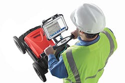
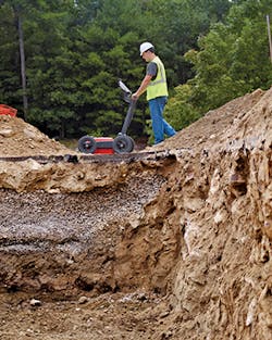
A GSSI utility scan
Utility Detection Methods and Technologies
There are several categories of utility detection technologies: magnetic, ground penetrating radar (GPR), passive sound detection, and location data recorders.
Magnetic detection can be used to find ferrous metals of all kinds used in the construction of conduits, pipe lines, power cables carrying an electric current, and communication lines transmitting a signal. Non-ferrous materials must be detected by other means. One of the oddities of magnetic detection occurs because the strongest signals come from the ends of the object being detected. This is because the ends are where the lines of magnetic force tend to concentrate. As a result, a vertically oriented object (even a small steel drum) can often be easier to find than a horizontally oriented cast-iron water main hundreds of feet long. This same effect occurs at the joints of this same water line where sequentially laid metal pipe segments join to form the pipeline. The magnetic detection display can show a series of aligned peak signals where these joints are located, providing information on the pipe’s alignment and depth by connecting the dots.
Though usually made of bundled copper wire, thin electrical power lines must usually be carrying a current to be detected magnetically. If a cable or line has been abandoned or is disconnected, operating the magnetic detector in direct mode can be used to induce a magnetic field. This is done by attaching a low voltage power source via clamps to the ends of the cable or pipeline. The result is a stronger signal running directly along the target alignment that allows for detection at greater depths and longer distances. Similarly, the transmitter operating in broadcast induction mode—after it is placed over the target line and activated—will also induce a signal that can be traced by the receiver.
As the magnetic detection unit operator walks over a buried line, the receiver generates an audio signal indicating when the operator is directly above the buried utility. When not above a utility, the receiver’s magnetic field sensors balance out the earth’s background magnetic field and produce a low frequency (about 40 Hz) audio signal indicating the absence of a utility line. The frequency of the audio signal increases as the operator approaches the utility until it hits its peak and then declines as the operator moves and passes over the line. Marking the surface locations of these peak signals will provide a visual indication of the utility’s location and alignment. Similarly, damaged electrical cables can be located by measuring the resultant voltage differentials in the soil.
Utilizing an electromagnetic antenna that broadcasted radio waves tuned to a frequency that can penetrate soils (including rock, concrete, ice, and other common natural and man-made materials), GPR provides a broader detection technology than the more narrowly focused magnetic detection technique. Though it has capabilities that make it suitable for obtaining geotechnical information as well as locating utilities, a GPR unit often requires more time to process data than simpler magnetic detection techniques and it tends to cost more. However, its abilities make it useful for outside of urban areas where natural conditions are dominant and utility locations are sparser than in cities.
GPR is functionally not much different than the more common aerial radar. By sending out pulses of high frequency radio waves, it can determine underground conditions from the radio waves that bounce back from solid objects such as buried utilities. These radio echoes bounce back to the surface where they are detected by the receiving antennae. The rest of the radio energy penetrates deeper into the soil until it encounters other objects and bounces signals back to the surface. The echoes delineate underground interfaces and surfaces such as changes in soil moisture and clay content, fractures and voids, cement chunks and solid pavement, gravel bedding, and man-made utilities. Increasing the transmitted radio frequency also increases the resolution of the radar reflections. Though its primary focus is on delineating regional hydro-stratigraphy, sensitive GPR units can also reveal the locations and depths of utilities.
In addition to avoiding existing utilities during general excavation and construction, a contractor may need to deliberately find a utility that needs repair. Such a search is usually performed for broken water mains when the precise location of the leak has to be determined. These leaks make noise which can be sensed by passive sound detection devices. Passive sound detectors allow operators to determine the location of leaks with highly sensitive ground microphones. First, they pick up noise from the water leaks that are transmitted along the pipelines themselves (sound vibrations tend to carry further and more clearly along the body of the pipeline). As the operator gets closer to the source of the leak, the noises get louder and fade as he or she passes beyond the leak. It is the point of peak noise that gives the location of the leak. This basic search technique can be augmented with a pair of spring-loaded snap lock-type pliers to the water valve. Attach a strong magnet to the pliers, and then listen for the leak. The water-leak noise will transmit through the valve, pliers, and magnet, into the sensor from a depth down to 6 or 8 feet, and at a distance up to 50 feet. This method can be used to isolate the two valves on which the leak noise is the loudest.
Once buried utility data is obtained from one or all of these techniques, how are these locations to be recorded? Locations can be noted by simple chalk marks or spray paint on surfaces, or digitally recorded in a sophisticated GPS computerized data base. Location data recorders included auxiliary field computers and GPS survey equipment. The result, especially when combined with computer-aided design (CAD) drawings of the site, can include changes in terrain elevation, existing utilities, property lines, roads, railroads, building foundations, rivers, and the site’s hydrogeologic features. And information from even the most sophisticated data recording system can be represented in the field by simple pint marks that visually guide the excavator operator.
However, earthmoving equipment today is guided by GPS, whenever possible. With these systems the utility detector can be connected to a GPS unit or a similar automated surveying device, and the information entered directly into the computer’s database. The computer can then display real-time CAD updates of existing site plan drawings as each newly discovered utility line is discovered. These can be combined with CAD drawings of the proposed grading plans to determine which utility and segments of the utility lines are to be affected by earthmoving activities. Survey data can then be entered into the system to record repair locations and changes in utility alignments.
Current Benefits and Coming Advances
What are the latest advancements in the utility detection industry and what will their impact be? Recent advances include scanners that scan the job site and automatically recommend the optimum search frequency based on local soil and construction conditions. Powerful 12-watt transmitters drive signals farther down large, direct-buried utilities. Dual output transmitters can now connect to two utilities at once. Transmitter frequency and power level can be remotely controlled from the receiver. Sensors now have the ability to detect the direction of the current to identify a utility target line. The allied technology of GPR has been advanced by newer computer chips, more memory, and other computer hardware improvements. In addition to these improvements, the systems have become more user-friendly and more accurate. This increased accuracy results from dual frequency antennas. With two frequencies available in a single antenna box, GPR can detect a wider range of utilities. Traditional frequency can detect objects that are buried more deeply while the secondary frequency detects shallower objects.
In addition to improved performance, utility technology advances have made these systems more user-friendly. The more advanced locator systems include four-button intuitive operators’ interfaces, high-contrast LCD displays visible even in direct sunlight, and multiple language text.
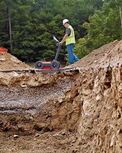
These recent developments represent significant advances over earlier detection technology. The earliest detection “technology” consisted of a diviner’s witching rods that would cross over each other as the diviner walked over the buried utility. From a purely mechanical “analog” device such as the diviner’s rods, today’s technology has evolved along the same lines as cell phone technology. With advances in technology have also come reductions in size. Early GPR units utilized large tape-to-tape electronic devices operated by a unit the size of a van. Today’s GPRs are either handheld models or wheeled units the size of a lawn mover.
But are extremely accurate utility detection tools necessary? What benefits does the contractor accrue from their use? Simply put, this technology affects the contractor’s bottom line. They reduce the risk of hitting a buried utility and the resulting costly damages. Accurate site knowledge results in more efficient excavation operations with less downtime, less risk, and increased productivity. GPR units especially have high degrees of accuracy.
The benefits of using utility detection technology include improved safety, operation efficiency, and cost savings. Short of manually digging test holes or relying completely on available site plans (which are never fully complete) a contractor doesn’t have much of a choice. At any construction site there are known unknowns—such as the depth of an electrical cable—as well as far more dangerous unknown unknowns, like a gas line whose location, alignment, and depth are not shown on any map drawing. Advanced utility detection technology eliminates both, allowing workers to work safely. It also allows them to work efficiently. Knowing where buried utilities are located allows excavators to properly plan and stage their work to minimize work stoppage and downtime. Avoiding accidents and delays adds to the bottom line by achieving significant cost savings.
The safety and financial benefits of current utility detection technology should be obvious, but in such a potentially hazard-strewn environment, what do operators need to be especially careful about in their inspections? Aside from the obvious dangers on a work site, the contractor needs to focus on established, solid procedures to maintain safe work conditions. In addition to internal procedures, external communications are also vital. This includes interviews with people familiar with the site, such as former owners, operators, government officials, and contractors.
Different technologies are required for detecting metal, plastic, concrete pipes, and fiber cables. Products used to locate metal or metallic lines are based on electromagnetic (EM) detection—technology that has been around a long time, evolving to make the detection method more familiar. Detecting non-metallic pipes and cables is technically more difficult, and is based on radar, sound, or other techniques that have physical limitations. GPR is capable of finding all kinds of pipe materials. Any solid object that differs from the softer surrounding soils shows up. The outlines of buried pipe trenches are also apparent on GPR scans. However, buried cables placed inside larger conduits may be difficult to locate, so GPR needs to be augmented by othertechniques.
Major Suppliers
Ditch Witch of Charles Machine Works Inc. provides a wide range of cable avoidance systems ranging in size from the hand held 150R/T to the large UtiliGuard locating system. The Ditch Witch 150R/T electronic locating system is a lightweight (just over 5 pounds), inexpensive tool for detecting obstacles beneath the surface. It comes with optional beacons to help trace water, sewer, or drain lines. The more powerful Ditch Witch 250R/T helps locate utilities even when signals are either extremely weak or extremely strong, while the high-frequency 830R/T is designed as a contractor-grade locating system.
Their UtiliGuard locating system includes numerous features, including the accuracy-enhancing Ambient Interference Measurement (AIM), which automatically recommends the best frequency. AIM scans the surrounding area for noise andrecommends the best frequencies for the fastest, most accurate locations. UtiliGuard has a powerful dual output 12-watt transmitter for sending signals deep below grade. This dual output can connect to two utilities at once, reducing the time required to locate multiple services. It can operate at 70 standard frequencies via user-configurable software.
For more than four decades, Geophysical Survey Systems Inc. has been the world leader in the development and manufacture of subsurface GPR and EM imaging systems. Their flexible data acquisition systems can be utilized and integrated with their radar antennas, providing a series of utility locating system options. These include the UtilityScan DF, a GPR unit used for utility locating. It incorporates digital dual-frequency antenna (operating at frequencies of 300 and 800 MHz). This dual-frequency antenna makes it easier to detect a wider range of utilities. Operator interface is provided by a touchscreen that can view shallow and deep targets simultaneously in a single scan. Advancements to these systems have given users the ability to perform filtering and corrections on the equipment itself. This allows users to troubleshoot and perform real-time onscreen improvements. The system can operate for up to eight hours while surveying at ground speeds up to 6.25 miles per hour. The UtilityScan is used to locate the position and depth of metallic and non-metallic objects, including utilities such as gas, communications, sewer lines, underground storage tanks, and PVC pipes, and allows operators to quickly identify and mark the location and depth of buried utilities. UtilityScan is the most popular all-purpose utility locating GPR system and can also convert to a concrete inspection system with various accessories. UtilityScan LT is a less expensive GPR unit based on UtilityScan. The UtilityScan LT is purpose-built and serves as an entry-level utility locating system.
Though it has been a supplier of innovative instruments for subsurface investigation and exploration for almost a century, MALÅ GeoScience USA Inc. has spent the last 25 years focused on the manufacturing, research, and development of cutting-edge, non-destructive ground penetrating radar solutions. The result is a broad and versatile range of ground penetrating radar equipment, from standardized systems to complex and embedded systems. These systems allow operators to efficiently collect,analyze, and transform ground penetrating radar data into understandable and correct visual representations of the subsurface. MALÅ GPR equipment is cost-effectively meeting the high productivity requirements of our users. Geoscience provides four MALÅ GroundExplorer solutions: the GX80, GX160, GX450, and the GX750. The GX Controller is built around a 1.6 GHz Intel Atom processor and using a high-resolution 1,024 by 768 pixel display to present the 32-bit data. Its interface is based on the MALÅ XV Monitor GUI.
McLaughlin utility locator systems feature gain controls and mode options that help the operator adjust to the necessary setting to prevent signal distortion. All of their utility locating equipment features multiple antennas to help filter out noise, and provide a clear accurate signal with accurate depth readings. Their Vision FLX is a cable locator that combines a state-of the art fault-finding system with a cable locator. It can perform cable tracing and depth calculations to pinpoint ground return faults on electric, CATV, and telecommunications cables. An optional Cable ID attachment can be used to identify energized or de-energized underground electrical lines in transformers, switch boxes, and excavations.
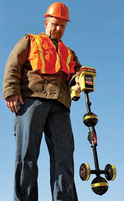
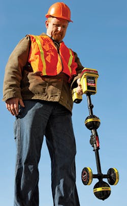
RIDGID is integrating wireless and mapping functions into their underground locating products. The SR-24 is RIDGID’s latest receiver, adding wireless and GPS features to their SR-20 utility locator. The SR-24 utilizes wireless Bluetooth communication to connect to external devices such as high-accuracy GPS units, compatible signal transmitters, and even smartphones. The SR-24 connects wirelessly to most high accuracy sub-meter GPS handheld devices with Bluetooth. In this mode, the GPS handheld device is the primary data capture point to obtain the most accurate position information, obtaining depth and signal information wirelessly from the SR-24.
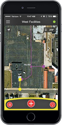
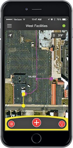
This can be combined with RIDGIDtrax, a free app for smartphones and tablets, to visually display GPS line traces in real time (having a nominal accuracy of less than 8 feet, with accuracy increasing with a clear line of sight to GPS satellites overhead). Its hardware includes its own GPS antenna on board for applications that do not require detailed sub-meter position information. It records GPS and location information with its onboard microSD card. This data is stored in a universal KML file which can subsequently be imported into GIS mapping programs such as Google Earth.
RIDGIDtrax is fully compatible with smartphone technology, eliminating the need for more expensive hardware displays and controls. The RIDGIDtrax app for iOS and Android can be downloaded onto an operator’s smartphone and used to operate the SR-24’s GPS. This app allows the operator to view positional information in real time to document underground assets by selecting the utility type (gas, electric, water, etc.) prior to walking the utility alignment. The completed KML map can be digitally shared via e-mail for reference by other users. In effect, it “paints” electronic markers on a digital version of the surface that reappear as the site is walked again in the future. In addition, SR-24 comes with long range wireless Bluetooth included in the new ST-33Q+ signal transmitter. This saves the operator the trouble of having to walk back to the transmitter to change frequencies since the ST-33Q+ can be controlled remotely from the sr-24 keypad.
Sensors & Software Inc. produces LMX100, a GPR unit designed with simplicity in mind. It can locate metallic and non-metallic utilities, utilities with broken tracer wires, and the disturbed soil often associated with utility burial. Balancing depth penetration, resolution, and accurate locating, subsurface data is collected in Locate & Mark mode; this provides a real-time image in the field to identify utilities and mark their locations. Their new Utility SmartCart can both locate and mark utility locations on the surface. Its survey and map mode provides location, mapping and SUM/SUE reporting capabilities. This includes full digital data recording while in Survey & Map mode. In combination with the EKKO_Project software, it can create depth slices from survey grids.
RIDGID’s SR-24 and RIDGIDtrax smartphone app
Subsite Electronics, a Charles Machine Works Inc. company, provides a comprehensive suite of electronic products including utility locators, HDD guidance equipment, and machine controls. Their UtiliGuard multi-frequency locator comes equipped with multiple accuracy-enhancing features, highlighted by AIM technology, which automatically recommends the best frequency. The UtiliGuard locating line offers an industry best IP65 environmental rating allowing functionality in dusty or dirty job-site conditions. The product also offers exceptional battery life saving time and money. The operating battery life of the transmitter is 100 hours, and the receiver 30 hours.
UtiliGuard also has a 12-watt transmitter that sends signals farther down the utilities. The display is highly visible in all conditions, including direct sunlight. The transmitter can be remotely controlled by the receiver which saves the technician time allowing them to control power level, frequency, and dual output functionality without walking back to the transmitter. Its use of Bluetooth technology simplifies communication and data transfer to other communication devices.
The UtiliGuard locator is direction enabled, providing—for example—the direction of the current to help you identify the target line. And by accurately providing both the horizontal and vertical distance (depth) to the utility, it enables users to determine accurate locations of obstructed utilities. Its AIM technology scans the surrounding area for noise and recommends the best frequencies for the fastest, most accurate locates.
By using a dual output transmitter, it can connect to two utilities at once, reducing the time required to locate multiple services. In addition to power, the system comes with built in flexibility provided by 70 standard frequencies via user-configurable software.
RIDGID’s SR-24 and RIDGIDtrax smartphone app
Underground imaging technologies (UIT) includes unique, proprietary geophysical hardware and software developed to acquire, process, interpret, and map 3-D subsurface data rapidly and efficiently. Their multi-functional data acquisition program simultaneously gathers geophysical and positioning information, and then employs a dynamic interpretation program to process, display, and interpret collected data.
Electromagnetic induction instruments are an important part of UIT’s geophysical toolbox, combining both electromagnetic detection and GPR capabilities. These instruments detect changes in the electrical conductivity of the subsurface by measuring certain attributes of waves received back from the ground after being transmitted from the system(s). These instruments are able to map metallic utilities, buried debris, and other areas of disturbance such as graves and simple soil changes. A benefit of these instruments is that they work to detect metallic items in soils unfavorable for GPR and do not require a connection to the utility.
By utilizing standard resistive fault locates (RFLs) from manufacturers such as Radiodetection and Vivax/Metrotech, UIT can further enhance its utility mapping capabilities. By either measuring the passive signals carried along a utility or by tracing an electromagnetic field induced onto an electrically conductive utility by a transmitter, it can read the signal strength in the field while placing a physical mark on the surface (which can later be surveyed) indicating the location of the buried utility. UIT also utilizes the SPAR300, an advanced RFL instrument coupled to precision GNSS and RTS systems, in select utility mapping applications. SPAR 300 is also able to quantify the error associated with the utility mapping measurements, which enables error bars and confidence levels to be determined and plotted. Further accuracy is achieved with the use of the 14 antenna TerraVision II array combined with single antennae GPR carts. This allows UIT to cover large areas of ground in a day and produce three-dimensional images.
Vivax-Metrotech Corp. is a worldwide developer of pipe and cable locators, CCTV inspection cameras, and water leak locating products—including their vScan locator, designed to make buried utility detection a simple and cost effective process. Its additional optional features like GPS, BT, and a buried metal cover mode allows an operator to work the system with minimal training.
Its latest development is the HL 50 Acoustic Water Leak Survey Tool. The HL 50 is designed for municipalities and contractors making leak surveys. Its acoustic properties, simple filter settings, large LCD and extremely long battery life ensure optimum efficiency. The HL 50 is a handheld device suitable for use by municipalities, contractors, plumbers, small water systems, homeowners, and other users. It comes with three filter settings that allow equipment to be perfectly adjusted to the individual task while suppressing interfering background noise. It is equipped with the sensitive GM80 wind protected ground microphone as well as a heavy duty contact microphone.
US Radar of Matawan, NJ, is manufacturer and distributor of surface-penetrating radar, also known as ground penetrating radar, systems. Their Seeker SPR technology was originally in the 1980s to locate plastic landmines. The company was formed in 1994 to adapt the military-grade GPR technology for commercial applications. US Radar develops its own software, hardware, and equipment engineering and manufacturing. It has recently begun production of its cost effective Q5C ground penetrating radar system that employs their SmartGain system’s digital clarity. It can be used for most GPR applications but is especially effective at detecting and locating utilities, infrastructure, and natural gas pipelines.
The basic Q5C operates at a frequency range of 300–1,300 MHz with a single battery operating the unit. It comes standard with a 1.9 GHz multi-core Intel Atom processor and 10.4-inch daylight-readable LED color display. “The US Radar Q5C unit is going to give contractors and municipalities that never considered buying their own radar unit the chance to put ground penetrating radar to work in their public works, environmental, and utility locating efforts,” says Ron LaBarca, president, US Radar Inc.
The US Radar Q5C model incorporates SmartStack, a unique algorithm that takes advantage of spare processing power to improve image quality and increase the depth of penetration. This is especially effective in soils that tend
to dissipate electrical energy. StreetSmart system’s onboard processing, also standard, eliminates the need for post-processing of information. This allows the operator to see and evaluate data in real time rather than go back to the office. “The cost of entry for the Q5C makes it worthwhile for anyone who’s been thinking about locating to give it a try. Yet, this workhorse delivers the most powerful GPR on the market for locating utilities up to 15 feet deep,” says LaBarca. Operators can build on base unit, adding functionality and additional performance to the base model. “Users can add capability both through hardware and software upgrades to build the base model into a top-shelf GPR unit,” says LaBarca.
Matching their hardware is their associated software, Version 5.0 of its Seeker acquisition software, which automates several key capabilities to help assure the accuracy of the overall system. Seeker 5.0 simplifies use of both the software and the GPR equipment by automating several crucial settings such as gain control, which adjusts the gain of the radar signal to enhance underground target identification and layer tracing. Seeker 5.0 also automatically recognizes and confirms the GPR system’s antenna and configures antenna-specific settings such as depth range and encoder interval. The software also includes an industry-exclusive override capability to enable experienced operators to manually set gain levels, and such features as soil condition calibration; geo-positioning and backtracking; data recording and storage; distance measurement; and highlighting and annotating specific locations, positions, and depths.
US Radar also offers the Quantum Imager, the world’s first ground penetrating radar system to use triple-frequency radar technology for locating and imaging objects at greater depths and with higher resolution than competitive single- or dual-frequency systems. The Quantum Imager excels in a wide variety of applications, from bridge deck analysis to locating and imaging utilities at depths up to 30 feet—twice the depth limit of dual-frequency systems and three times that of single-frequency units. The Quantum Imager applies ultra-wideband pulses that combine the advantages of pulse radar and stepped frequency radar. The system effectively renders high-resolution imagery of underground objects.