Modern earthmoving operations require a contradictory balance. They must combine the brute force of massive earthmoving in order to maximize productivity, with the finesse of accurate control so as to minimize the cost of unnecessary soil removal. The brute force part is easy to visualize in any piece of heavy equipment with its large bucket or blade powered by high horsepower diesel engines and operated by equally powerful hydraulic systems. What is not readily apparent (aside from perhaps the antenna affixed to the blade, bucket, or body of the equipment) is the GPS guidance and control system that insures superior accuracy in soil removal and placement. The first ensures that the job is done quickly and efficiently the second that the job is done according to plan without wasted movement or unnecessary effort. Together, they maximize equipment productivity.
But how much is due to the brute force, and how much is the result of finesse? When taking the plans of a project and translating them into moving dirt, where does the productivity increase when using machine control and GPS? Earthmoving jobs are easy to plan back at the office. Out in the field, things are always different. By combining GPS tracking with AutoCAD generated surface files, a contractor can achieve both precise control and a general overview of the project. This allows a contractor to execute the project plan as needed while adjusting filed operations as necessary. Furthermore, he can do so in real time providing an extra boost to productivity by minimizing any delays.
In addition to monitoring and directing the operations of a single machine, a fleet owner can use GPS to allow for a holistic approach to managing the site, expertly choreographing equipment movements to maximize efficiency. The tools of for achieving this include not just the positional locations of the equipment, but also hard data relating to equipment utilization and activity, time onsite, duration of tasks, if equipment is being underutilized, or if it is subject to too much idle time. Revised surface files of excavated areas can be downloaded at the end of each workday so that daily earthwork volumes can be calculated. This output can be compared with the vehicle utilization data so that actual work can be compared with industry norms or anticipated productivity. Once this information is available, the operator can project out completing dates to ensure that a project remains on schedule.
So it is not a question of why a contractor would use GPS. Rather, since the advantages are so obvious the quest in why would any contractor not us this technology. To stay cost competitive in today’s market, equipment owners need tighter controls and more extensive oversight to ensure that every piece of equipment is being utilized to its maximum potential. GPS along with other business analytical software provide the “God’s-eye” view of the work site. And while it can’t work miracles, GPS tracking makes possible a proactive project management strategy that reduces operating costs, wasted time, and physical risk.
The obvious usefulness of GPS is reflected in actual industry utilization rates. According to the “2016–2017 Fleet Management Technology Report” (a survey of equipment fleets about their use of GPS tracking), 41% of construction companies in the United States are currently equipped with GPS tracking. The use of GPS by independent contractors also tracks to this rate. GPS has established itself as a standard operating technology for the construction industry and earthmoving project. It is no longer an option, but a necessity.
What Is GPS and How Does It Work?
GPS is a product of the Cold War. Developed by the US military during the President Reagan years, this system consists of a series of 24 satellites in geosynchronous orbit. That is, these satellites remain in the same fixed location in the sky. Out of 360 degrees of longitude, each satellite covers a 15-degree sweep of the globe. They orbit the earth twice each day, broadcasting a timing signal. These signals can be intercepted by ground antennae mounted on ships, tanks, planes—or the buckets and blades of heavy earthmoving equipment.
Though, like all broadcast signals travelling at the speed of light, there is a small-but-measurable time lag between the signals from adjacent satellites. The difference, measured in milliseconds, allows for the triangulation between the ground antennae and the satellites emitting the signal. This triangulation measurement allows for the measurement of the precise location (measured in latitude, longitude, and elevation above sea level) on the surface of the earth where the receiving antennae is currently located. As is true so often in the history of technology, a technical advancement meant for use in war has been modified and adopted for peaceful civilian applications. A system intended to track the movements of men, weapons, ships, and war planes is now used to follow the movements of commercial shipments, find lost hikers, and guide construction equipment.
GPS guides equipment operations through their Automated Positioning Report System (APRS). Using triangulation between the several of the system’s broadcasting satellites allows for positional measurements with accuracies up to 30 centimeters (1 foot). The use of APRS increases this accuracy to 1 centimeter when used in conjunction with GPS. What APRS does is integrate GPS with the equipment’s controls. An APRS replaces the manually operated hydraulic drive cylinders traditionally used to control the movements of an excavator’s arm or dozer’s blade with electronically controlled servo-type valves. These servos send an electric current that creates magnetic field that rotate suspended armatures, that are further connected to fixed flapper arms. These flapper arms provide the linkage to the rotary spools that increase and decrease hydraulic pressure to the hydraulic systems. These are part of the closed-loop hydraulic system that controls the direction, flow rate, and applied pressure of the hydraulic fluid.
Going from individual pieces to equipment to an entire fleet of equipment or trucks is also easily managed by GPS applications. This allows a fleet owner to coordinate and choreograph the movements and activities of an entire fleet of earthmoving equipment and also track the locations of trucks delivering material to the site or hauling dirt away for disposal. Like pieces on a chessboard (or, more accurately, objects in a video game) these activities are tied to an onsite digital terrain model (DTM) of the project site. This is a three-dimensional (3D) model created by an AutoCAD program, which utilizes a patchwork of connected triangles. The corners of each triangle is defined mathematically by three special coordinates (northing, easting, and elevation). While not a perfect match (no model ever is) to the actual terrain, this geometric surface comes the closes to matching actual surfaces. This is especially true for post construction or excavation surfaces, which tend to be regular and smooth.
The software interacts with the model and the equipment hardware via sensors attached to the business end of the machine (the edge of the dozer blade, the teeth of an excavator bucket, etc.). These sensors continuously record and update the movements of the equipment using the same 3D location system as the DTM. The sensors relay their current location back through the system to the operating controls, which in turn direct the movement of the equipment in accordance with the programmed DTM for the proposed construction surface or excavation grades.
Coordinating all of the mobile GPS sensors on each piece of equipment is a stationary GPS sensor combined with an antenna with a receiver called the base station that is set up adjacent to the operating area. The base station is permanently located over a pre-surveyed reference point, such as a third order benchmark that has been established by ground survey. If necessary, some relative location (manhole rims, street curbs, and building corners, etc.) whose elevation is not exactly known but can be treated as a local datum for the project area can also be utilized for ground antennae setup.
The hardware for these control signals consists of a control box connected to the servo valves via electrical cable, which, in turn, connects to the hydraulic control system that physically moves the equipment. It is the incoming satellite data from the GPS system that tells the equipment where it is. The DTM design files are stored in a compact-flash memory card, memory stick, or accessed externally from data broadcast by the site’s controlled area network (CAN). The database, CAN, and GPS operate in real time to place a blade or bucket exactly where it needs to go and move it so that it accomplishes its task with the need for rework or wasted effort. All three elements, mobile sensors, base sensors, and equipment operator are in continuous communication with each other. The blades and buckets simultaneously move back and forth, up, and down in combination to achieve the desired movement.
Where and When Is GPS Best Used?
As described above, the advantages of using GPS guidance systems are legion. Using advanced systems, an operator can increase productivity by greater than 50% compared to purely manual operations. The increase in productivity comes indirectly by the avoidance of having to perform rework at the site. Guided by GPS, an equipment operator can get his cuts and placements right the first time. Furthermore, material wastage is minimized. GPS doesn’t necessarily increase the number of productive hours per day so much as it makes every hour a machine is active much more productive.
This has all sorts of secondary benefits and cost savings. Getting the most out his earthmoving equipment allows a contractor to get the most out of his workforce as well. This reduces labor costs, another costs savings, while reducing the impact of local labor shortages—always an issue in a booming economy with a considerable amount of construction activity. Furthermore, grades and elevations can be checked in real time as the work is being performed. The operator can check his elevation from within his cab as he is working. There is no more need to stop work at regular intervals and have a manual survey performed of the work zone to check its accuracy. In the past, the accuracy-checking task has traditionally relied on a crewmember inside the trenches to manually check depths and slopes. Now with these systems, the need for that task is greatly reduced—thereby cutting job site costs and improving crew safety. This traditional cause of equipment downtime is mostly avoided with the use of GPS.
Giving operators the tools to perform accuracy checks also gives greater responsibility, initiative, and job satisfaction. The additional training that the operators receive has the effect of empowering them, increasing senses of purpose and self-worth. This alone has a marked, if indirect, impact on productivity. By eliminating rework and improving employee morale, any money spent training operators on GPS is a wise investment that pays for itself very quickly. Human factors also show improvement in the area of site safety. The precision guidance and ability to choreograph equipment movement across a busy site improves safety by maintaining safe work zones, avoiding known utility locations, preserving the foundations of existing structures, and maintaining a safe flow of traffic.
GPS systems are often augmented by laser guidance for precise finish work. Lasers can compensate for some of GPS limitations. GPS works best with an open sky and no significant overhead blockage. (For example, GPS is not used for tunneling operations.) Laser guidance stations and targets mounted on equipment blades can work in any outdoor situation, with or without overhead blockage from trees and tall buildings. GPS, however has a much greater effective operating range, limited only by the availability of open sky. Lasers systems are usually limited to about 1,500 feet. GPS can allow for the construction of complicated surface models as well as flat, sloping surfaces. Lasers, being line of site instruments, are usually limited to operations on long, flat, or sloping surfaces. (Though they, too, can build surfaces as directed by a 3D design model represented by a surface AutoCAD file.)
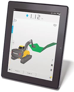
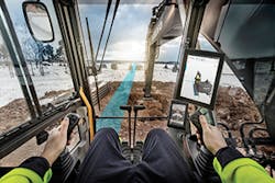
The Dig Assist system gives the operator a real-time, 3D view of the machine’s movements, providing total synchronization between bucket and high-resolution display.
Piling Not Filing
So, why use GPS, and what are its advantages? It should come as no surprise that every contractor is in business to make money. Productivity is time, and time is money. In an evermore competitive industry, no contractor can afford to not use every possible advantage to minimize costs, successfully bid jobs, and satisfactorily complete the job in a timely and cost effective manner. And the job doesn’t end when the last of the dirt has been dug up and placed.
As the old saying goes, “the job is not done until the paperwork is finished.” And, the physical act of actually moving the dirt is only part of the job. The grading, excavation, backfilling, and placement of structural fill have to be properly recorded, surveyed, and certified. Traditionally, this paperwork for excavation and grading sites consisted of manual surveyor records of shots taken on a grid system or at regular intervals along break lines. These shots would be recorded manually and serves the basis for as-built contour grading plans and bank volume measurements. In order to keep a project on track, conform to the desired design plan, and ensure the effort was headed in the right direction, survey shots would be taken a regular calendar intervals or at key milestones in the project schedule.
GPS changes all that and completely automates a contractor’s filing and document needs. The resultant savings can be substantial, since office overhead is a significant cost on any construction project. And, it is not just the direct production of the record documents that is labor intensive and costly. Each recorded survey entry has to be checked thoroughly and manually in the absence of an automated surface checking system. Staff can be reduced both in the field and back at the home office. This, of course, requires greater training both for the equipment operator actually doing the earth moving and his foreman in the filed trailer. The training represents a necessary upfront cost that can be considered to be part of the capital expenditure associated with adopting GPD. But, it is money well spent.
Unfortunately, the use of GPS and machine control is still in the early adoption stage, but growing fast. Generally speaking, the construction industry as a whole has a way to go before complete adoption of GPS guidance systems. According to the 2016–2017 Fleet Management Technology Report, which surveyed fleets about their use of GPS tracking, 41% of construction companies in the US are currently equipped with GPS tracking. Globally, marketing studies indicate that GPS machine control penetration rates for applicable machines is at less than 20%. Greater adoption of GNSS and machine control technology should continue at increased rates of adoption. Approximately 25,000 machine control systems sold annually. These consist of both factory-installed or dealer-installed, two-dimensional (2D) and 3D systems.
GPS Application Philosophy and Approach of Leading Suppliers
According to Scott Hagemann, Product Application Specialist for Caterpillar Inc.,
Productivity can be measured in many ways: time savings, labor costs, material costs, fuel costs, quality bonuses, and finish bonuses. It begins as early as the job layout. With Machine Control and GPS, you don’t have to wait for someone to stakeout the project or weather that permits someone to stakeout. This allows you to get started sooner. Any design change will also benefit as productivity increase due to not having to wait for restaking. As the operator starts moving material you will see great value in being able to move the correct amount of material, to the correct location, the first time. This, along with only using the exact amount of material, will translate into a productivity savings. You can also use GPS by having job layouts of the site so the machines or supervisors’ tablets can have the precise storage locations of materials, job trailers, or site boundaries. This can help having the right things in the correct location or, better yet, not in the way, therefore reducing excessive handling of material.
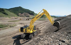
A Komatsu PC490LCi-11 hydraulic excavator
GPS Insight and its robust GPS fleet tracking systems provide in-depth reporting to help manage employee productivity and monitor vehicle and equipment utilization. Proactively monitoring how quickly employees can complete jobs, time onsite for the duration of the project, and how equipment is being used or underused, allows managers to correct mid-course to keep the project moving on schedule. It’s a more strategic approach to job site management and can have a significant impact on how efficiently jobs are completed. Utilizing both GPS tracking and intelligent business management software allows contractors to stay on top of vehicle and equipment locations and utilization, reduce costs and risk, implement a proactive maintenance strategy, and create the best training and procedures for operators to follow.
Komatsu America Corp. has demonstrated its expertise with GPS by getting a new construction company on its feet. Kingston Services of Des Moines, IA, had little name recognition or experience. Fortunately, the operators starting the company (Dan Hutton and Charlie Bowman) for a sister company, MPS, had an extensive background in the latest construction-related technology. While others were learning GPS, Kingston used it right out of the gate. Starting with just a laser screed to handle concrete jobs, they expended by changing their focus. Moving into large-scale concrete contracting, Kingston now has 50 employees and performs about 20 contracts a year, including dirt work for grading and pipe laying projects.
Dig assist machine control system Co-pilot
“We began performing our own dirt work subgrade and utilities, because it prevented headaches for us,” notes Hutton. “Now, we can go to a job site and use the same CAD files and technology on all phases of the project, and we have much greater control.”
And, they owe it to smart use of GPS, especially with Komatsu equipment. “Having so much experience with the new technology gave us a definite advantage,” recalls Hutton. “The GPS technology made up for our lack of experience. We could start and finish jobs quicker. If a customer wanted us to begin a project immediately, we could accommodate that because we didn’t have to wait to put in the stakes. The technology helped us complete more projects in a shorter time, without sacrificing quality. Speed is great, but accuracy is better.”
Two machines that have been instrumental in Kingston’s success are its GOMACO GT-3600 curb-and-gutter slipform paver with stringless technology, and a Komatsu intelligent Machine Control D51PXi dozer with integrated GPS. “The D51i uses the same Topcon technology as our GT-3600, so we are able to get precise results,” says Hutton. “The D51i allows us to work and grade in a higher gear than we can with other brands equipped with aftermarket systems. When we grade with our D51i and pave with the GT-3600, we save time and material, and we can get within a sixteenth of an inch to spec.”
GPS technology has helped the company grow in its early years, and Hutton expects that it will become even more of an asset moving forward. “Kingston is a young company, and so is its staff. Much like the choice to embrace technology, the decision to hire youthful workers was also made out of necessity. The younger employees naturally gravitated to the technology, but even the seasoned veterans have been enthusiastic converts. Most of our employees grew up with computers in their hands, so it’s nothing new for them,” adds Hutton. “Even our older employees have gotten on board. We did a street widening with our GT-3600, and an employee nicknamed ‘Grandpa’ couldn’t understand why we were using all of the technology. Once we finished, he was blown away by the speed and accuracy. He’s a believer now.” GPS, in partnership with Komatsu, gave the company its success.
Trimble’s machine control technology puts the project design in the cab, at the operator’s fingertips, and then helps guide and control the bucket or blade to the desired location. This takes the guesswork out of moving dirt, which provides substantial productivity gains. For grading, the in-cab display shows the position of each tip of the blade and automatically controls the blade to the design elevation, enabling operators to achieve finished grade to millimeter accuracy with fewer passes when fine grading. When used on an excavator the GNSS receivers and gyro-compensated sensors measure the precise 3D position of the teeth or bucket, helping operators perform complex tasks and simplify finishing slopes with accurate positioning. It is estimated that companies will see time and cost savings in the 20–50% range with machine control, with the technology often paying for itself on the first project. On dozers, machine control provides better blade control and faster operating speeds, enabling operators to grade higher quality surfaces as much as 40% faster. Similarly, grade control solutions for motor graders, scrapers, and wheel loaders eliminate guesswork and makes it easier for less skilled operators to perform precision work, freeing up more experienced operators for more complex jobs. Trimble is meeting a significant need in the construction industry through its global SITECH distribution network. SITECH dealers have the construction technology expertise to provide contractors and operators with insight on how to best implement technology solutions for their field operations. They do so by providing training and support to ensure contractors are successful using Trimble machine control and other technology solutions for all of a contractor’s applications.
According to Jena Holtberg-Benge, Director, John Deere WorkSight:
Machine Control along with the Base/Rover technology improves the contractor’s overall efficiency on and off the job site. In pre-planning contractors can use this technology to verify plan quantities when bidding jobs. This technology also gives the contractor a tool to measure job site progress and also know how much material the machine moved. This information can then be correlated with other costs associated with running the machine to determine an actual cost per yard of material moved. Information such as this along with all the other benefits of machine control really fine tunes the contractors bid and gives them a competitive edge.
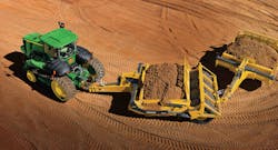
This edge comes in the form of significant cost savings. These can be quantified and John Deere has done so.
Takeuchi US has a unique approach to fleet asset management, an approach that emphasizes operational flexibility. Takeuchi Fleet Management (TFM) helps the owner mange his fleet and minimize costs via remote monitoring that checks the mechanical health of the equipment. This monitoring will detect problems and minimize repair work by keeping track of alerts while capturing run hours and equipment data. Their proactive monitoring increases machine health, reduces risk, and keeps machines running by scheduling maintenance based on run hours.
Matt McLean, Product Manager, GPE products for Volvo Construction Equipment expresses Volvo’s philosophy this way:
Machine control systems can drastically improve productivity through better management of the overall project. Site managers can visualize the tasks being done in real time and reallocate machines more effectively as soon as tasks are completed. At the operator level, machine control systems allow for digging with greater accuracy, in less time and with less rework. For instance, with Volvo’s new Dig Assist machine control solution, the operator can view, via our Co-Pilot interface, on-screen indicators showing when target grade and depth are achieved—as compared to the project plans.
Volvo’s equipment guidance system, Dig Assist, has a number of advanced features including real-time bucket visualization with indicator lights to help guide the operator to meet the target grade and avoid over- or under-digging. Their Quick Measure allows an operator to easily measure distances and determine angles between points, such as along trenches, across foundations, or down slopes. Its In-Field Design function allows the operator to draw custom digging profiles without the need of an engineer or surveyor including 3D performance, without the need to refer to back-office generated terrain models. And its Material Layers function gives an operator the ability to preset the different depths for trenching and backfilling and observe the progress onscreen in real time.